DC Snow Storm Alert: 10 Things to Do Before Saturday Hits
How to Prepare for the Winter Weather Event
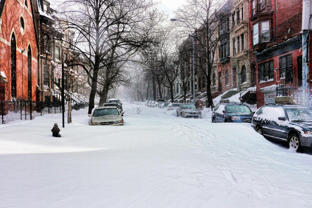
Since everyone is talking about 2016 on social media, do you remember Snowzilla? The legendary Blizzard of 2016 that dumped up to 29 inches of snow on the DC metro area, shutting down the federal government for days and leaving the region buried under feet of powder? While forecasters aren’t predicting Snowzilla-level totals, this weekend’s storm could still pack a serious punch.
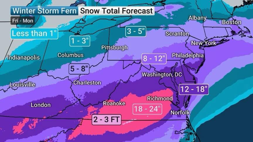
The DC area is tracking a potential significant winter storm this weekend that could bring substantial snow Saturday afternoon through Sunday, along with record-breaking cold temperatures. Forecast models are suggesting anything from 2 inches to 12 inches, though the European model has consistently shown potential for over a foot of snow in the DC area over the last couple of days. The storm is forecast to develop Friday in the Southern United States and could produce hazardous winter weather stretching from Texas to southern New England.
What to Expect:
- This will be a pure snow event with light and fluffy snow
- Heaviest snow will fall south of DC
- Temperatures likely struggle to make it above freezing Friday afternoon and quickly dive through the 20s and into the teens
- Frigid cold follows with highs only in the 20s from Saturday through next Thursday
While meteorologists are still tracking the exact path of the storm, it’s better to be prepared than caught off guard. There will be a strong area of high pressure around that could push this system to our south, giving us very little or no snow, but there’s a very good chance for at least some snow. Here’s your essential prep checklist:
1. Stock Up on Essentials
Grab groceries, medications, and any supplies you’ll need for a few days. This includes non-perishable food items, bottled water, prescription medications, and basic household supplies. Remember that the storm could impact deliveries and make getting out difficult for several days. Just don’t go full Snowzilla mode and clear out all the veggie flaxseed tortilla chips like people did back in 2016.
2. Prepare Your Vehicle
Fill up your gas tank, check antifreeze levels, and make sure you have an ice scraper, shovel, and emergency kit in your car. The roads could be treacherous Saturday night through Sunday. Consider adding blankets, a flashlight, jumper cables, and a phone charger to your emergency kit.
3. Charge Everything
Power up your phone, laptop, portable chargers, and any other devices. While major outages aren’t expected, it’s always smart to be prepared. Having fully charged devices ensures you can stay connected and informed even if power issues arise.
4. Check Your Heat
Make sure your heating system is working properly. Frigid cold is expected to follow the storm, with highs only in the 20s from Saturday through next Thursday. This is the time to test your system and address any issues before the deep freeze sets in.
5. Stock Ice Melt and Shovels
Get rock salt or ice melt for your walkways and driveway. If you don’t have a good shovel, now’s the time to grab one. These supplies tend to sell out quickly once snow is imminent, so don’t wait until the last minute.
6. Prep Your Home
Bring in any outdoor items that could blow away or get buried. Check that your pipes are insulated, especially if you have any exposed plumbing. Frozen pipes can lead to costly damage and major headaches during already difficult weather conditions.
7. Plan for Work
Coordinate with your team about remote work plans. Federal offices closed during the last storm earlier this month, so there’s a good chance similar closures could happen this weekend. Make sure you have everything you need to work from home if necessary.
8. Know Your Snow Removal Plan
Whether you’re a business owner or homeowner, make sure you know who’s responsible for clearing sidewalks and when. Many jurisdictions require property owners to clear sidewalks within a certain timeframe after snow stops falling. During Snowzilla, DC spent $41 million on snow removal from the storm, largely due to last-minute contracts signed without negotiations.
9. Stock Up on Entertainment
If you’re stuck inside, have movies, books, or projects ready. This could be a good weekend to catch up on indoor activities you’ve been putting off. Download content ahead of time in case internet speeds are affected.
10. Monitor the Forecast
Keep checking weather updates as the weekend approaches since the track could still shift. The timing is looking like late Saturday PM into Sunday, with the European model starting the snow a little later Saturday night, which means we could still be looking at flakes Monday morning. The snow is most likely to begin Saturday night into Sunday morning, continue through most of Sunday and end Sunday night.
Understanding the Forecast Range
Why such a wide range of 2 to 12 inches? High pressure could act like an atmospheric brick wall that blocks storms, pushing the system south and giving us minimal snow. However, if the storm tracks closer, we could see significant accumulations. Don’t trust a weather app or social media post promising 18 to 23 inches of snow — meteorologists expect to share more precise snow total predictions no more than 48 hours before the storm.
What Weather Alerts to Watch For
The National Weather Service may issue various winter weather alerts as the storm approaches:
Winter Storm Watch: Issued when there is potential for significant winter weather within 48 hours. A watch doesn’t mean it will happen, only that it’s possible.
Winter Storm Warning: Issued when significant winter weather is happening or about to happen.
Winter Weather Advisory: Issued for conditions that can still cause major travel trouble but don’t meet warning criteria.
Because the air mass this weekend may be extremely cold, the NWS may also issue Cold Weather Advisories or Extreme Cold Warnings for dangerous wind chills.
This Isn’t Snowzilla (Probably)
For context, Snowzilla officially measured 17.8 inches at Reagan National Airport, tying with the 2010 Snowmaggedon for the fourth largest snow storm on record for DC. Dulles Airport measured 29.3 inches of snow, its second largest snowfall on record, while BWI Airport came in at 29.2 inches, its largest on record. The storm affected approximately 103 million people, with 33 million placed under blizzard warnings, and more than 13,000 flights were cancelled.
While this weekend’s storm isn’t expected to reach those historic levels, it has the potential to be one of the more impactful snowstorms in recent memory to impact our region. Brace for potentially messy travel conditions on Sunday and the possibility of school closures or delays on Monday and even into Tuesday.
Stay Safe
Remember, it’s always better to over-prepare than to be caught unprepared. While the exact snowfall amounts are still uncertain, the combination of potential heavy snow and prolonged bitter cold makes this a weather event worth taking seriously. The cold temperatures mean any snow that does fall is not likely to melt away anytime soon.
The First Alert Weather teams across the DMV will continue to update the forecast this week as the storm track and details come into better focus. Stay warm, stay safe, and check back for updates as the weekend approaches.


DC Made a New Law to Stop Ticket Resellers
The new rule limits how much extra people can charge to resell...

The Supreme Court Just Gutted Black Voting Power
Breaking – Civil Rights In a 6-3 decision, the court’s conservative majority...

Teyana Taylor Takes the Lead as ESSENCE Festival Eyes a Cultural Comeback
For years, the ESSENCE Festival of Culture has stood as one of...

Sinners Makes History at the Oscars as Ryan Coogler and Michael B. Jordan Lead a Night of Black Excellence
Hollywood’s biggest night turned into a celebration of culture, storytelling, and long...


Leave a comment